 |
BRADWELL TO SOUTHMINSTER 2015 - August - 15 |
|

Our Walk
On our walk this sunny Saturday we explored the eastern part of the - still very rural and quiet - Dengie peninsular as well as the furthermost part of St Peter's Way. St Peter's Way is a reasonably long distance path linking Ongar, close to London, with the historic St Peter's Chapel in this eastern outpost of Essex. We started from the old church of Bradwell-on-Sea, following the even older old Roman road to St Peter's Chapel.
We take a short break at the remote St Peter's Chapel, built in 654 AD by St Cedd of Lindisfarne.
From St Peter's Chapel we headed south for about two miles along the sea wall. A sharp turn westwards brought us through arable fields to historic Tillingham's village green. After light refreshment at the "Fox Hounds" we headed west again along St Peter's Way over - for hereabouts - reasonably high ground, affording distant views out towards the Blackwater Estuary in the north. Near St Lawrence we left St Peter's Way and headed south to Southminster, from whence we caught our train back towards the crowded metropolis. Walking weather was excellent: sunny but with sufficient cloud cover to make sure we kept cool.
And now here is some verse to introduce the story of our walking day. My modest poetic endeavours can, I'm sure, be far outshone by others with more artistic mastery of our language than I have.
|
'Twas good walking weather this Saturday - just right to complete the St Peter's Way. At noon, from Bradwell's centre our feet did tread to St Peter's, the ancient chapel of Saint Cedd. Then to the sea wall and wide open spaces, with sun and fresh sea air in our faces. After traversing Dengie's green and fertile land, a light refreshment in old Tillingham was just grand. And so to our journey's high point we did advance, and 'twas the distant Blackwater our eyes could glance. Southwards now, off St Peter's beaten track, and on to Southminster for our journey back. Thank you Ralph for this walk devising and to all for your pleasant socialising. |
So here's what you will see on this page. If you joined us on our walk, I hope this page will bring back some memories of this pleasant CLOG Saturday. If you were not fortunate enough to join us, then I hope you will at least get some flavour of what this part of the wilds of remote Essex has to offer the discerning hiker from the crowded South East. I wish you happy perusing!
- Bradwell & St Peter's Chapel
- Tillingham
- Southwards on High Ground
- Southminster
- Features of Our Walk - for those who like to wax numerical
- Thankyou everyone for our nice day!
- Here are some "Technical Footnotes"
- And now just a little matter of administration. Thanks!
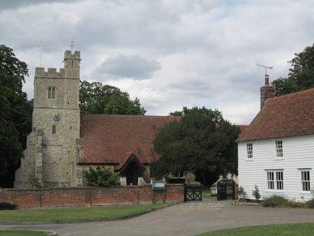
Bradwell & St Peter's Chapel
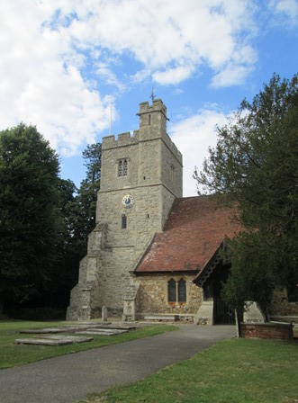
We set out from Bradwell-on-Sea just past noon. Busses in this part of Essex are not that frequent, and Ralph did well to optimise the timing of the train and bus connections. The old church of St Nicholas merits a quick look. However, it is historically eclipsed by the 7th century St Peter's Chapel which we reach after about two miles further east along an old roman road. After a short break at the chapel, we then head south along the sea wall. We are almost down to sea level in a vast, quiet and exposed landscape, with the sea out to the east and the fertile flat lands of the eastern Dengie to the west. An interesting experience in the crowded South-East.
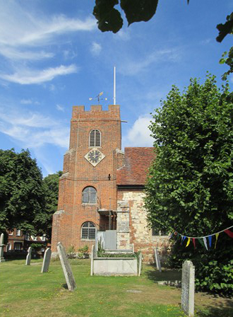
In Bradwell, we have a quick look around St Thomas's Church
with its 14th century nave and chancel and a tower built in 1706.

The Royal Coat of Arms has a strange looking lion and looks a bit "plasticcy" - is it genuine?
Whether genuine or not, the Coat of Arms certainly represents a version we don't have today.
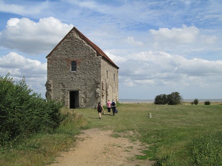
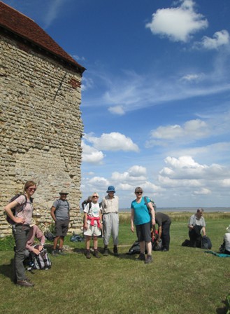
We then reach St Peter's Chapel standing gaunt in the wide open sea scape. It was built in 654 AD by the missionary to the Saxons, a missionary with the name of St Cedd. The visitors in this picture are not Cloggies but give an idea of the size of the structure.
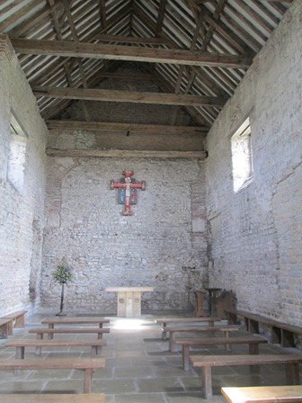
After many years being used for agricultural purposes, the chapel was restored for religious purposes in 1920. Here we can admire its simple, yet starkly impressive, interior.
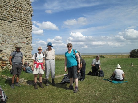
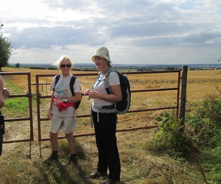
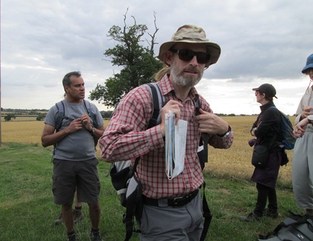
Now here are some of us Cloggies, refreshed after our short break ...
... and here we are again!
Land, sea and sky - and to realise that we are still in the crowded South-East!
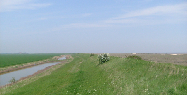
And here, on the same theme of wide open space is a picture I took on Saturday, 10th May 2008, near to the same spot. In the left distance you can just make out St Peter's chapel, two miles away.
Tillingham
After leaving the sea wall, we strike inland and westwards, passing a recently sprouted wind farm ere we reach Tillingham, where we have a short refreshment stop at the "Fox and Hounds". We are then ready to continue along St Peter's Way, leaving the village by the old village pump - could it but talk, the stories it would tell!
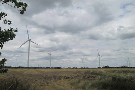
In some ways, wind turbines have an elegance all their own and are supposed to be environmentally a good thing. However, their intrusion on the landscape and the cost of putting them up, are often quoted as counter-arguments.
Tillingham's village green has been designated a conservation area and is presided over by
St Nicholas's church, parts of which date back to the 12th century.
The crenellations on the church tower hark back to the times when churches had to be defended from marauders, perhaps in Tillingham, coming from the sea.
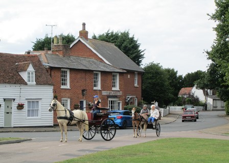
To a Victorian, the word "gig" would have had a significance different from that to which we are accustomed today. Here we see two gigs affording their occupants a nice Saturday ride.

On Tillingham's village green, across from the church, we have another institution spiritual - here the "Fox and Hounds". After partaking of some suitable beverages, we gather, strengthened and ready for the next phase of our walk.

We leave Tillingham by the old village pump, around which the locals must have gathered to exchange the latest village gossip.
(On this page, this is the second - and last - picture that I took on my previous visit to Tillingham on Saturday, 10th May 2008! All the other pictures on this page are brand new - honest!)
Taking the High Ground to Southminster
High ground in these coastal parts means anything approaching 30 to 40 metres. Nevertheless, we get good views to the Blackwater Estuary to the north. This estuary allowed sailing barges to reach Maldon, an erstwhile trading port, famed for its sea-salt.
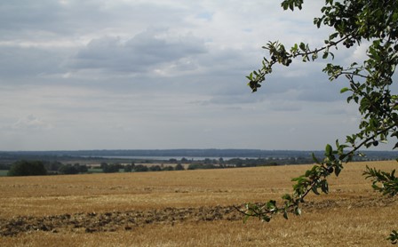
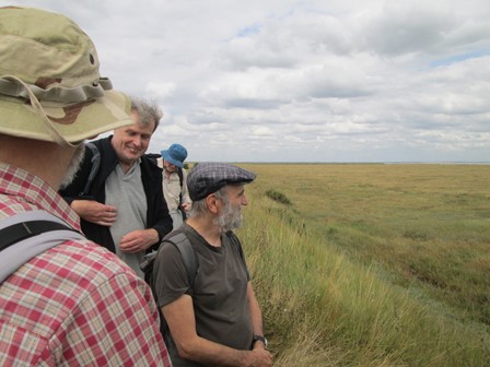
Here we have a view across the landscape to the Blackwater Estuary ...
... and here are some of us enjoying the said view.
Southminster is in our sights, and Ralph's work is nearly done - after leading walks over several consecutive parts of St Peter's Way from Ongar to Bradwell.
Southminster
Having arrived early this morning, I took the advantage of nosing around down-town Southminster. However, since this is where we finished our walk, it seemed a good idea to put this morning's pictures here. I was lucky that a churchwarden of Southminster's interesting church just happened to be in the vicinity, and, since I looked respectable (!!), was kind enough to let me into the church itself.
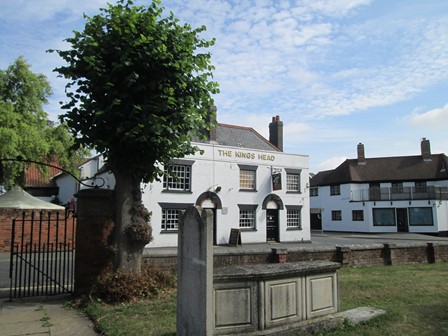
At the end of our walk, some of us stop for a quick beverage at Southminster's "King's Head", which hostelry, as is so often the case in other villages, is just opposite the church.
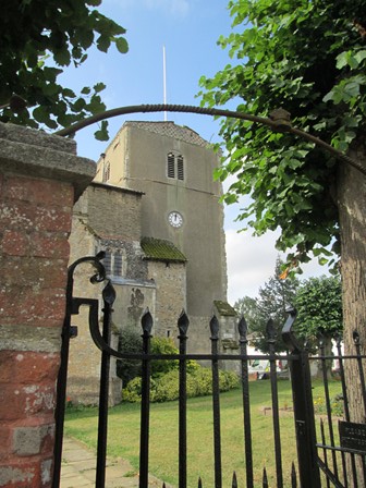
Southminster's St Leonard's church dates mainly from the 15th century. Walking around it, one sees a notice exhorting visitors to beware of falling masonry! The tooth of time has seemingly gnawed away relentlessly in Southminster, but the church is still standing!
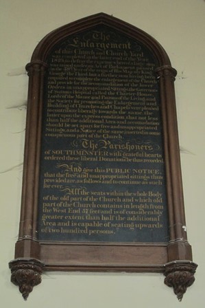
Indeed, it was only a short time ago, in 1819, that the church received its latest architectural and structural upgrade! At least this is what the plaque in the church tells us, listing all the kind benefactors for these improvement works.
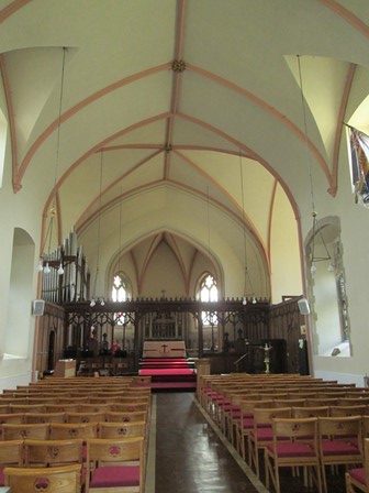
Elegant Regency simplicity is what greets Sunday worshippers in this church.
|

Towards the back of the church there is a very old yellowed and mellowed framed print depicting the hectic goings-on at the decisive Battle of Trafalgar in 1805. In particular we see the scene on HMS Victory with Admiral Lord Nelson who had just been wounded.
What's the connection with Southminster? Well one of Southminster's rectors was the Rev Alexander John Scott who was personal chaplain to Admiral Nelson. After the battle Britain's famous admiral died in the arms of his chaplain.
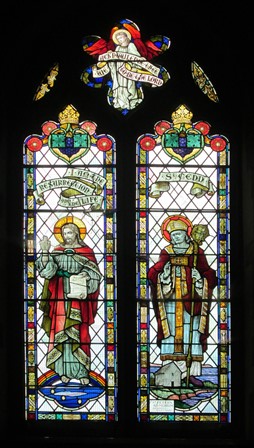
During WWII, Bradwell, with its airfield, was in the front line. Southminster was not in a very much safer position, and several stained glass windows in its own church were lost. So whether this window dates from pre-WWII or post-WWII, I do not know. It depicts Christ on the left. On the right is St Cedd, and at his feet is his Chapel of St Peter which we saw today near the start of our walk.
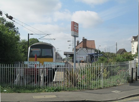
The railway came to this part of Essex late in the Victorian age and survived Beeching because of the proximity of the now de-commissioned Bradwell Power Station. Here is what the end of the line, which you see on the diagrammatic railway maps, actually looks like!
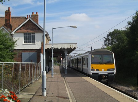
And here is the train ready to return to Wickford. The journey officially takes 31 minutes to Southminster, and 30 minutes returning. Why the difference? Well, it's only one minute!
Features of Our Walk
The first half of our walk of about 12 miles or 20 Km was along the initial part - or was it the final part? - of St Peter's Way, and was very close to sea level. Later, we reached higher ground (a maximum of 34 m., to be precise). It was essentially a low-level walk. However, the terrain had its challenges, including the reasonably freshly ploughed fields along the course of St Peter's Way. On the return route to Southminster, some footpath signs had succumbed to the joint ravages of weather and time. All was, however, doable, especially for seasoned Cloggies!
Now prepare ye for some plots and graphs. Not too overwhelming, but hopefully quite interesting! You will see here:
- An Outline Map of Our Walk
- Height Profile of Our Walk
- Some Facts and Figures
- Average Rising and Falling Gradients
- Gradient Profile
- Less Quantifiable Considerations
- Timing & Speed
Outline Map of Our Walk
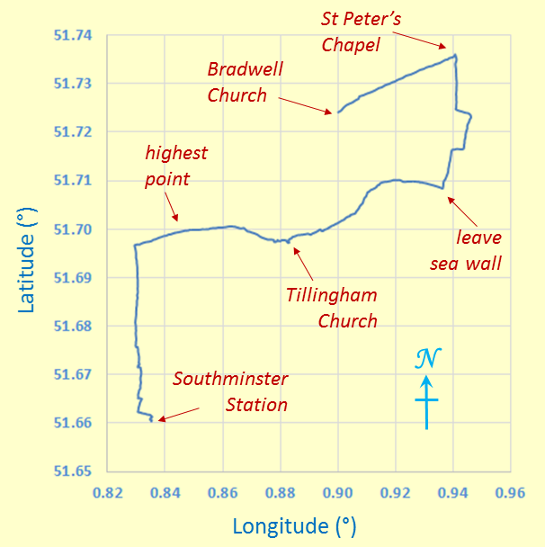
Outline Map of Walk
Our walk had the shape of a reversed letter "S". Here are few numbers. The minus signs for the longitude angles indicate "degrees west of Greenwich". The map grid scales translate to 1.112 Km per 0.01° latitude and a mean of 0.689 Km per 0.01° longitude, all when using 6371.0 Km as the volumetric mean radius of the earth - as per the WGS84 standard!
Because we don't live on a flat earth - unless you are a convinced "flat-earther" - maps are inevitably a distortion of what is. In other words, it's all a matter of mapping a curvaceous surface onto a flat surface. We don't want to carry curvaceous representations of the terrain on our walks, do we? In our case, the northern length of our map grid is stretched out by an extra 0.20 %, to make it the same on the page as the length of the southern part of our map grid. Not that much for hiking purposes really! Can't complain.
Height Profile of Our Walk
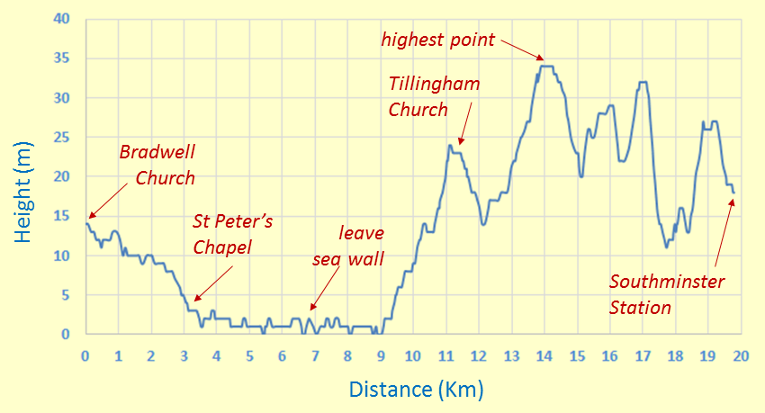
Height Profile
Much of our walk was very close to sea level. It was in the latter part of our walk that we scaled the - for hereabouts - dizzy height of 34 m.. It of interest, as we can see from this plot, that in past centuries people were savvy - they generally built their settlements on the highest ground they could find! Why get wet feet if you can avoid it?
Some Facts and Figures
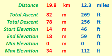
"Walk facts and figures"
Here are some "vital statistics" in metric and imperial units. The total distance, as always measured on a conceptual "flat" plane at mean sea level, is 12.3 miles or 19.8 Km. This accords with Ralph's figure of 12 miles. Of course, the total ascent (here 82 m) usually exceeds the difference between maximum and minimum elevations (here 34 m); I'd suspect things, if the reverse transpired!
Average Rising and Falling Gradients
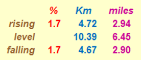
Rising and Falling Gradients
And here, for the numerical fun of it, are the average gradients we overcame on our walk. The rising and falling (negative) gradients are both averaged over the distance given, with level stretches having rises and falls of less than ± ½ metre. By comparison, Hertfordshire County Council recommends that its roads should not have longitudinal gradients of more than 5% and one of the steepest adhesion railways in the world, in Austria, has a maximum gradient of 11.6%. By way of further interest, the clockwise route of the Fairfield Horseshoe in the Lake District has a total distance of 15.62 Km (9.71 miles), with the following calculations: an average rising gradient of 14.66% over 6.589 Km, a level part over 0.345 Km, and an average falling gradient of 11.11% over 8.676 Km. This is seen by many as really quite challenging - but then, when you compare it with our Saturday Dengie walk, it can be said that on our excursion we had a more leisurely and less demanding aim compared with Lakeland challenges!
Gradient Profile

Gradient Profile
The plot represents the gradient (rising - positive, falling - negative) at each measured point of our walk. As some of you know, differentials are notorious for introducing noise. I have done some mild smoothing by looking at the gradient over the two neighbouring points either side of each central reference point on the horizontal distance (x) axis.
While it can be expected that gradient values tend to bounce around around the 0% level during a walk, this plot also shows that starting and finishing gradients here are - as is the case for most walks - other than 0%.
As might be expected, the gradients are greater in the hillier area of our walk. However, maximum rising and falling gradient are below 5% and 6% respectively. Interesting if you like that sort of thing - I mean, not in theory but out on your walk!.
Less Quantifiable Considerations
On any walk there are considerations which are very real but tantalizingly out of ready reach of those who wish to espouse a numerical approach to many of life's activities.
- Weather: On this walk we were blessed with good walking weather: we had some sun but also some cloud cover. It was not too hot or humid and not too cold. Parts of this walk, especially along the sea wall, are actually quite exposed, and could thus provide extra challenges in very hot weather (sun burn etc.) and in very wintry, cold and stormy weather.
- Ground Conditions: We had to cross three or four reasonably freshly ploughed fields. This was doable for us Cloggies, but actually meant good solid footwork and assumed good walking shoes as a definite pre-requisite.
- Signposting: Between St Peter's Way and Southminster, the path was poorly signposted, probably owing to the ravages of time and the elements, and an apparent unfortunate general lack of upkeep. This required careful navigation and made a map indispensable. (Well done Navigator Ralph!).
Timing and Speed
It's one thing to discuss the terrain over which we walk. It's quite another to ask how we personally respond to walking over that terrain. There are a number of considerations, of which timing and speed can be taken as starting points.
- Timing: Because of public transport considerations, we had to start our walk at about 12:10. We arrived back in Southminster at about 18:10. In between we had a number of rest stops, totalling at least one hour. This meant our walking time did not exceed five hours.
- Speed: Considering that our walk was about twelve miles in length, our average speed was thus about (12/5) miles per hour, yielding a walking speed approaching 2½ miles per hour. Hiking speed can vary between at least 4 mph for the extremely active and 1½ mph for those of the downright relaxing persuasion. We probably espoused a reasonably healthy "in-between" value!
Thanks
Thank you Ralph for organising and leading this walk, without undue hesitation or deviation. Thank you all for your good company. It certainly has been a nice and successful day out - lots of nice countryside and good exercise AND excellent weather for doing a walk in the far-flung reaches of deepest Essex. A rewarding way to spend a Summer Saturday!
Technical Footnotes
There are at least three aspects which I could raise here, including the behaviour of your browser, the behaviour of Windows 10® and general items buried elsewhere on my site.
- Browser Behaviour: If your browser appears to be lazy and does not want to load all the pictures, a friendly press on its refresh button might just get your browser out of its recalcitrant ways.
- Windows 10®: This is the first web page I have attempted using Windows 10®. So far so seemingly good, and hopefully my continuing experience - and indeed that of other new users - of Windows 10® will remain positive!
- More Technical Items: Whilst I have not had a chance to update the technical items on my "Read Me" page, you might find some further relevant things here.
Eric Scharf
Original: 2015-08-18 @15:20
SAGAX REX HANC RETIS ORBIS PAGINAM PINXIT ANNO MMXV.
© Eric Scharf 2015