 |
Epping-Ongar Railway MAPS HEIGHTS 2006-2016 |
|
| Where ? Boundary Map Heights Figures Timing Track Finally History Read Me |

Features of the Epping-Ongar Railway
The Epping-Ongar Railway (EOR) is the closest standard gauge heritage line to London. Its approximately six miles traverse attractive rolling Essex countryside, roughly parallel to the first part of the Essex Way from Epping Station via Ongar to the coast. The places the EOR serves, namely North Weald, Ongar and nearby Greensted, are steeped in history. The EOR was a branch of the Great Eastern Railway (GER) and has a pedigree going back to 1865. As befits a heritage line, the EOR boasts steam and diesel traction. Presently, the two stations open to visitors of the public are Ongar and North Weald - both these are the original stations built in 1865. The provision of a further station within walking distance of Epping (LUL) is being actively considered. Heights on the EOR range from 45 m up to 116 m Above Sea Level (ASL); the latter point lies between Epping and North Weald and was the highest point on the whole of the former GER.
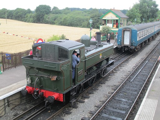
At North Weald, visiting GWR pannier 6430 prepares to take the train to Ongar.
Now prepare ye for some plots and graphs. Not too overwhelming, but hopefully quite interesting! You will see here:
- An Outline Map of the EOR
- Boundary
- Height Profile of the EOR
- Some Facts and Figures
- Timing & Speed
- Track File
- And Finally
- History
Where is the EOR?
The Epping-Ongar Railway (EOR) is the closest standard gauge Heritage Line to London, with Epping and Ongar Stations being respectively about 17 and 21 miles from the centre of the Capital. The centre of London is officially taken as the intersection of The Strand, Whitehall and Cockspur Street. This intersection is often referred to as Charing Cross, not to be confused with the nearby Victorian Eleanor Cross itself, nor the station in front of which the cross stands. An outline map and the detailed distances and bearings are as shown below.
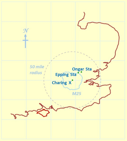
The EOR is just outside London's M25.
Whilst the EOR is close to London, it actually lies in the County of Essex and is just outside the M25. The EOR and its attractive and historic surroundings are certainly sufficiently close for most to warrant a day visit from London.
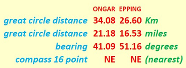
Here are the detailed distances and bearings for the EOR.
Epping LUL-EOR Boundary
The LUL has responsibility for Epping station. The line from Loughton to Epping was double tracked in 1892, indicating that, even then, Epping Station had become an important transport hub. Today, daily commuters come in to Epping from afar afield as Bishop's Stortford and Chelmsford.
For the EOR, a presence close to Epping station would, of course, be very attractive. This is not just for the EOR, but also for growing communities such as Ongar and North Weald, who would welcome easier rail access to the Capital. Indeed, the aim for the EOR is to have a station within easy walking distance of Epping Station LUL, but at present it is too early to make any definitive statement. On the EOR, the 9.4 Km (5.84 mile) Post marks the limit of normal running. (Note that distances on the EOR are measured from the 0.0 marker at the buffer stop at Ongar. Surprisingly, this is also still the reference for distances on the whole of the London Underground!) The actual boundary between the LUL and the EOR is at a point between this 9.4 Km Post and Epping LUL.
For completeness, Epping Station (LUL) is included in descriptions below of maps and heights, whilst recognizing the present realities of the boundary between the LUL and the EOR.
Outline Map of the EOR
The EOR traverses about six miles of attractive Essex countryside with its historic places, churches and time-honoured buildings. The EOR runs roughly parallel to the first part of the Essex way, which for 82 miles links Epping Station (LUL) to Harwich. It should be emphasized that Epping Station is a descriptive anchor point; the reference to it on this web page still recognizes the present realities of the boundary between the LUL and the EOR.
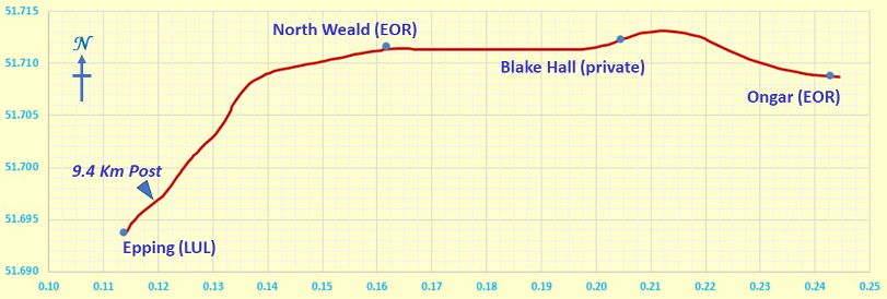
The Epping-Ongar Line is about six miles long.
Figures on the vertical and horizontal axes represent degrees latitude and longitude respectively.
Height Profile of the EOR
Heights on the EOR range from 45 m up to 116 m Above Sea Level (ASL). At least three aspects can be noted here.
- Highest point on the old GER. The 116 m point lies between Epping and North Weald and was the highest point on the whole of the former GER.
- M11 Overbridge. The first dip from North Weald towards Epping is (I believe) to accommodate the lowering of the track bed below the M11 over bridge. The M11 was built after the electrification of the EOR was to take Underground trains of a "tube stock" height; the track bed had to be lowered to take the heritage rolling stock, most of which have heights conforming to main line dimensions.
- Station planned close to Epping LUL. This station could be on a gradient; this aspect will probably need to be woven into the plans for a possible new station close to Epping LUL.
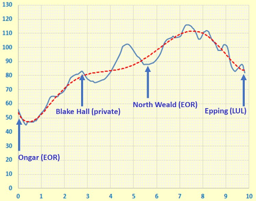
Height Profile
Y and X axes are in units of metres and kilometres respectively.
Origin. The above plot uses a true origin for the vertical elevation (height) axis, so as not to lose track of reality. What a worthy aim!
Trend. To show the general trend in the heights, the following 6th order polynomial fit, marked above in red dashes, has been used.
Topographical Facts and Figures for the EOR
Here are some "vital statistics" in metric and imperial units. The total length of the journey is 9.4 Km or 5½ miles. It's not a completely smooth climb from Ongar towards the 9.4 Km Post near Epping. The total ascent exceeds the difference between maximum and minimum elevations; I'd suspect things, if the reverse transpired!
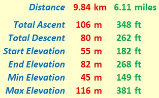
"Walk facts and figures"
Timing and Speed
It's one thing to discuss the terrain over which we travel, but it's quite another to consider how the locomotives - steam and diesel - respond to travelling with a train of perhaps four, possibly fully laden, carriages over that terrain.
If it takes 15 minutes (according to published timetables - see link) to cover the 3.48 miles between North Weald and Ongar, this gives an average speed of just under 14 miles per hour. This is well within the usual maximum speed allowances for heritage railways, and of course, allows passengers time to appreciate the pleasant landscape as it glides past.
Track File
If you are keen to see the railway route superimposed on an Ordnance Survey® (OS) map, then you can use the following file to do so. The numerical data in this file were plotted by me. Hence the data are presented on a "best efforts" basis.
And Finally - a Matter of Practicality
Any map is an approximate representation of what is. Practicality and scale are relevant considerations. We are not dealing with a planning application calling for detailed spatial descriptions of intricate boundaries. However, notwithstanding, I hope my humble endeavours on this page are nevertheless interesting for, and useful to you, my reader!
The maps in the history section below are not of my making, but their sources are, I hope, clearly indicated!
History
Here I have added some excerpts from old maps, excerpts which highlight the historical aspect of the EOR and of some of its immediate neighbourhood. The Ordnance_Survey® maps are sourced from the Map Section of the (National Library of Scotland (NLS)), who state the restrictions in place on the commercial re-use of these maps. The maps were originally printed using Heliozincography.
These "map excerpts" highlight the two-fold purpose of rail transport towards the end of the Victorian era. Both freight and passengers were carried - usually in separate trains. Each station thus had a goods yard with sidings and supporting buildings. Nowadays goods yards have become car parks or places for heritage lines to store their rolling stock. Turntables for the steam locomotives were to be found at the larger and more important stations. Stations were not always close to the centre of places they were built to serve; horse and cart, horse and gig or merely "shanks pony" were how the locals got to their rural railway stations.
The station buildings on the EOR date back to the opening of the line in 1865. The Victorian maps you see here, were published in 1896.
For the aerial views of today, I have also added access to the relevant Google Maps©.
Here are the stations - then and now.
Ongar,
Blake Hall,
North Weald,
Epping
Ongar
At Ongar the "famous" cemetery is just across the road to the east of the station. (See link). There is one passenger platform but there are quite a few goods sidings. There is one turntable and an engine shed on the north side of the station. The signal box (S.B.) at the passenger platform has now been replaced by a "look-alike" imported from elsewhere on the former GER. "L.B." at the station building indicates "Letter Box" and emphasized the importance of railways for carrying not just passengers and freight, but also the "Royal Mail".
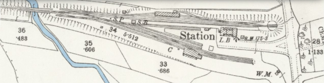
ONGAR STATION
Great Britain, Ordnance Survey County Series 25 inch/mile - 1841-1952
Essex (1st Ed/Rev 1862-96) LI.9
Surveyed: 1874, Revised: 1895, Published: 1896
https://maps.nls.uk/view/104189999
© Google Maps
Collapse display side panel with arrow on left or with "Esc".
Zoom in/out at lower right of display.
Blake Hall
The Blake Hall country residence is about 1 mile north east from the station which bears its name. Greensted Green, to the south, is much closer to the station. However, as the railway passed through the estate of Blake Hall, the owners of Blake Hall felt they should have a station with their name, and the rest is history. The station never saw much traffic and the station master probably had a much quieter existence than many of his counterparts elsewhere on the GER. Two goods sidings completed the rural picture. The signal box (S.B.) is no more. There was no need for a turntable here since trains would normally proceed to, and terminate at, Ongar. There did not appear to be any letter box at Blake Hall.
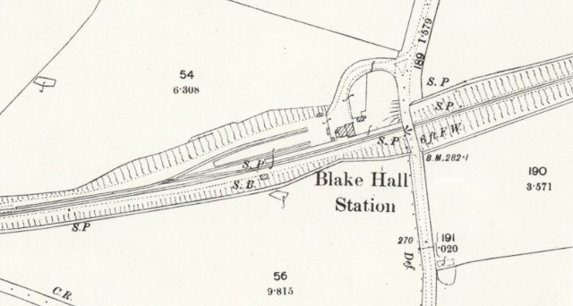
BLAKE HALL STATION
Great Britain, Ordnance Survey County Series 25 inch/mile - 1841-1952
Essex (1st Ed/Rev 1862-96) L.12
Surveyed: 1873-4, Revised: 1895, Published: 1896
https://maps.nls.uk/view/104189960
© Google Maps
Collapse display side panel with arrow on left or with "Esc".
Zoom in/out at lower right of display.
North Weald
Judging by the track work, North Weald station was busier than Blake Hall Station. However, there was still only one platform and no turntable. However, there was a letter box at North Weald Station. The signal box was on the other side of the platform. North Weald aerodrome would come in the 20th century and would provide some additional traffic.
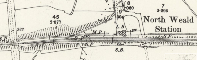
NORTH WEALD STATION
Great Britain, Ordnance Survey County Series 25 inch/mile - 1841-1952
Essex (1st Ed/Rev 1862-96) L.11
Surveyed: 1872-3-4, Revised: 1895, Published: 1896
https://maps.nls.uk/view/104189957
© Google Maps
Collapse display side panel with arrow on left or with "Esc".
Zoom in/out at lower right of display.
Epping
The line from Loughton to Epping was double tracked in 1892; however, the revision of this map in 1895 does not appear to reflect this. The bottom left of the map shows only one line heading south, with a "path" for the missing line. In addition, if we look, near the top right, at the road bridge to the left of Station Road, we can note that the line to Ongar on one side of the bridge and the line coming out of Epping Station on the other side of the bridge, appear to be staggered and not linked as they should be.
These observations apart, Epping appears to have been a busy place in 1895, judging by the number of lines, sidings and buildings in the goods yard. There is also a turntable and what is probably a two-road engine shed next to the turntable. A car park now occupies the goods yard and engine shed. Time moves on!

EPPING STATION
Great Britain, Ordnance Survey County Series 25 inch/mile - 1841-1952
Essex (1st Ed/Rev 1862-96) L.14
Surveyed: 1872, Revised: 1895, Published: 1896
https://maps.nls.uk/view/104189966
© Google Maps
Collapse display side panel with arrow on left or with "Esc".
Zoom in/out at lower right of display.
Eric Scharf
Original: 2021-05-04 @11:12
Update: 2021-10-30 @12:55
SAGAX REX HANC RETIS ORBIS PAGINAM PINXIT ANNO MMXXI.
© Eric Scharf 2021