 |
GODALMING CIRCULAR 2015 - August - 01 |
|

Our Walk
Our Saturday walk was ably led by Tim, a stalwart when it comes to leading walks! After negotiating the affluent "suburbs" of Godalming we headed for Tuesley with its quarrying associations. The "Star" in Witley was our lunch stop. Then we passed Enton Mill and headed uphill to Hydon's Ball - a place steeped in history and affording distant views over the Surrey countryside, to Hindhead and beyond. Taking a different route, we returned via the Busridge Lakes to Godalming with its busy High Street and iconic "Pepper Pot". Tim laid on a nice cream tea for us - a fitting finale to another nice sunny, but not too hot, CLOG walk.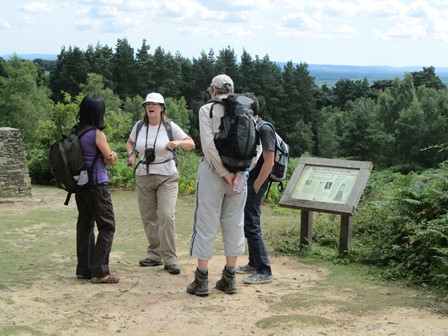
We had about twenty CLOGGIES on our walk.
Here are some of us enjoying our pleasant interlude on Hydon's Ball.
And now for a bit of playful verse. I'm sure you can wax more poetical than I, but I felt I wanted to summarise our experience in my modest way before continuing our narrative.
|
This Saturday 'twas to Godalming we went, and to us fine weather indeed was sent. On past Godalming's old water mill our steps then advanced straight uphill. We saw Bargate Stone was once quarried here, much prized for local houses, it did appear. Then through Tuesley and past Milford Station, with Witley's "Star" our lunchtime destination. Suitably refreshed we marched past Enton Mill, ready for Hydon's Ball - that historic hill. To Hindhead and further our eyes could verily see, and all around the landscape was in its Summer glee. Back to Godalming we then made our descent. Via the High Street and the Pepper Pot we went. But ere we thought our walk was done, Tim's tea and scones beckoned us to come. Tim, thank you for your fine Surrey walk. Of an excellent Saturday we indeed can talk. And everyone can doubtless agree, how good to finish with your nice cream tea. |
Godalming - Here We Come!
We assembled at Godalming's Victorian station (1859, LSWR) and then made our way through slices of Godalming's history and then through its "suburbs" which exuded affluence and prosperity at every pore.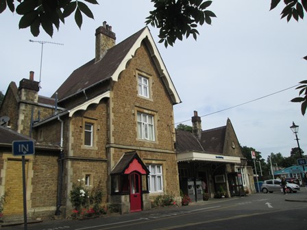
Early birds had a chance to browse through Godalming's railway history as presented by an array of photographs gracing the station's arrival hall. The station itself dates from LSWR days when railways were new-fangled technology. Today, our modern day technology didn't quite get its act together, for there was signal trouble further down the line at Liss - this meant a delayed start to our walk, but only by about 15 to 20 minutes.
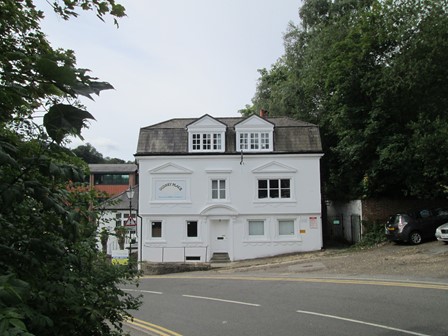
"Surrey Place" (Luxury Office Suites) greets us as we leave the station forecourt.
Looks like dazzlingly bright Georgian - perhaps a good omen for our sunny day.
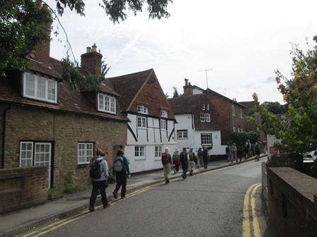
We pass some more chunks of Godalming's past: this row of picturesque old houses and ...
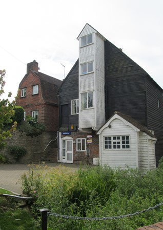
... opposite, an old water mill straddling a tributary of the River Wey.
Path to Witley
We leave Godalming via an erstwhile quarrying area for Bargate Stone, a type of hard sandstone (yes, sandstone is usually quite soft!) used for many traditional local buildings hereabouts. Tuesley, next on our route, was a centre for the quarrying activities for this stone, as names on its houses testify. Onwards we go, past Milford Station on the London-Portsmouth Line, until we reach "The Star", our lunch stop in Witley.
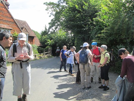
We make a short water stop in Tuesley ...
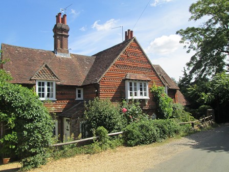
... and admire the traditional houses.
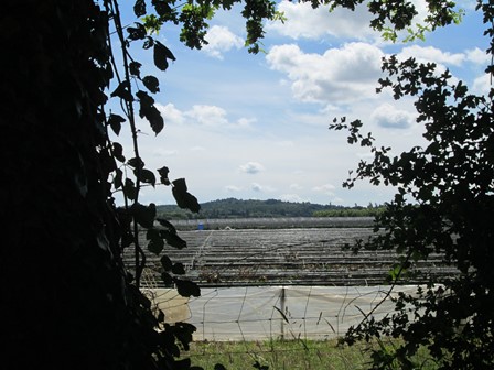
Further on, we catch a distant view to the south, of Hydon's Ball, our afternoon destination ...
... whilst enjoying the rolling sun-soaked Surrey countryside.
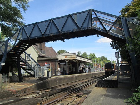
We come to Milford Station, ...
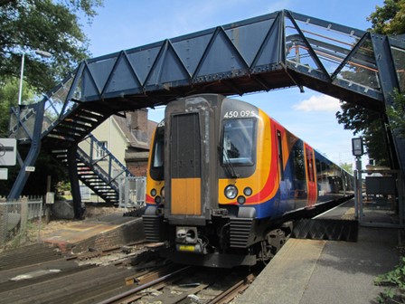
... and let the "Portsmouth Flyer" pass before proceeding, past hidden lakes, to Witley and lunch.
Lunch at the Star
In Witley we stop for an hour or two at "The Star", a traditional looking inn, whose prices reflect local affluence. We enjoy the verdant and shady "beer garden" before proceeding, past Enton Mill, to the dizzy heights of Hydon's Ball.
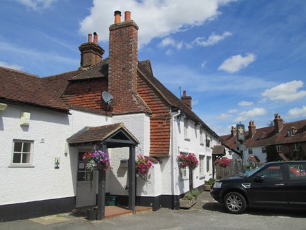
The Star (food rating 4/5) appears to be somewhat short-staffed today, but the pleasant food and drinks add to the quality of our Saturday walk. The Stowell's Cider is certainly refreshingly nice on a day like this.
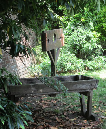
In the garden we espy what look like traditional village stocks, harking back to an era when
- as it seems from today's viewpoint - justice was sometimes meted out in a very summary fashion.
What on earth the wooden structure in front is, remains, for now, a mystery.
After leaving the Star, we pass Enton Mill. Grinding corn and cereals is now longer its purpose; it now glories in its new incarnation as a group of pleasant residences for the quite well-off.
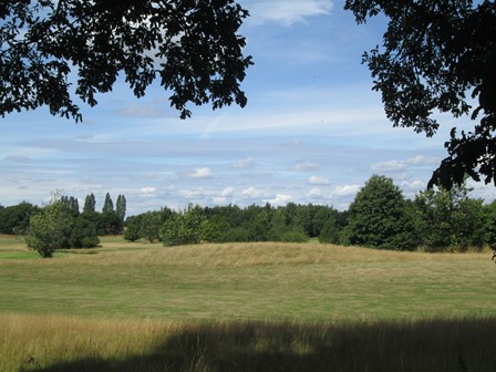
Hydon's Ball
We climb up to to Hydon's Ball, at 179 m, the highpoint, geographically and scenically, of our walk. It and the surrounding heath were bought as a kind of memorial to a certain Octavia Hill, one of the founders of the National Trust in 1895 and an ardent campaigner for the well-being of the poor. The "Ball" in the name is thought to be associated with a component of a semaphore system, although Hydon's Ball apparently did not form part of the erstwhile nearby famous London to Portsmouth chain of semaphores. Anyway, we tarry awhile to enjoy the view, some refreshment and a chat about all sorts of things, before descending on to our way back to Godalming.
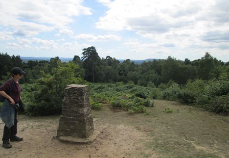
The triangulation point "marks the spot".
Heathland and distant views towards Hindhead "characterise the spot".
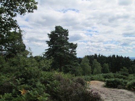
Yes, it's nice country side in all the verdant glory of summer.
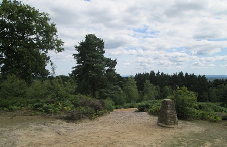
Triangulation points, whilst harking back to the now outdated 1930s way of producing maps,
still make for nice focal points on hill tops.
After reading about some historical facts on the display board, there's time for a chat
about life and everything ...
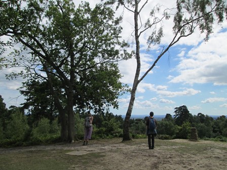
... and for a little exploration of the hill top before our descent to Godalming.
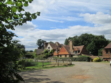
Return To Godalming
From Hydon's Ball we descend to Godalming via the Leonard Cheshire Home and Busbridge Lakes. Godalming's iconic "Pepperpot" in the busy High Street, and the historical parish church grace our route. Most of us have time to rise to higher things, for we accept Tim's nice invitation of cream teas at his house. This means climbing to the heights above Godalming, which physical exertion makes Tim's scones and tea extra specially welcome. After visiting Tim at home, we make our descent to Farncombe Station for our return to the Metropolis. A pleasant day was had by all!
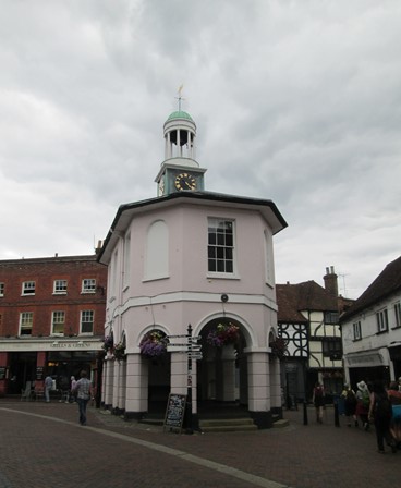
Godalming's famous "Pepper Pot" was built in 1814 as a new town hall. Was there really enough space in which to conduct the local administration? Apparently not, but after a spell as a local museum, it is still used for public functions.
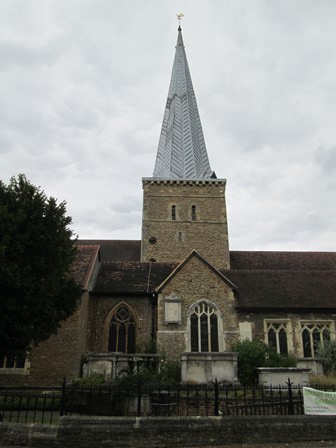
Godalming's Parish Church of St Peter and St Paul is a Grade I listed building, essentially dating back to about 1100 and boasting an early Saxon chancel (of course pre-1100) and a Norman tower. It is closed today except for the organist, whose mellow music
wafts down the traditional streets of Godalming.
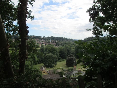
On the way up to our cream teas, we have a chance to appreciate this verdantly framed view of Godalming - parish church, Pepper Pot and all.
Features of Our Walk
Our Saturday walk was ably led by Tim, who read about this walk in a local magazine. This makes the walk extra special, for it really is based on local knowledge! In order to place this walk in a more general context, I assumed a deviation of a few hundred yards back to Godalming Station, instead of including our nice "cream tea" visit to Tim's house. In other words, to keep our description as general as possible, we have assumed a direct return to our starting point - unfortunately not everyone who wishes to repeat this walk will have the chance to savour Tim's nice cream teas! If we are allowed to assume a circular walk back to our starting point, then we are talking about 9.4 miles of 15 Km, with the main climb reserved for the afternoon.
Now prepare ye for some plots and graphs. Not too overwhelming, but hopefully quite interesting! You will see here:
- An Outline Map of Our Walk
- Height Profile of Our Walk
- Some Facts and Figures
- Average Rising and Falling Gradients
Outline Map of Our Walk
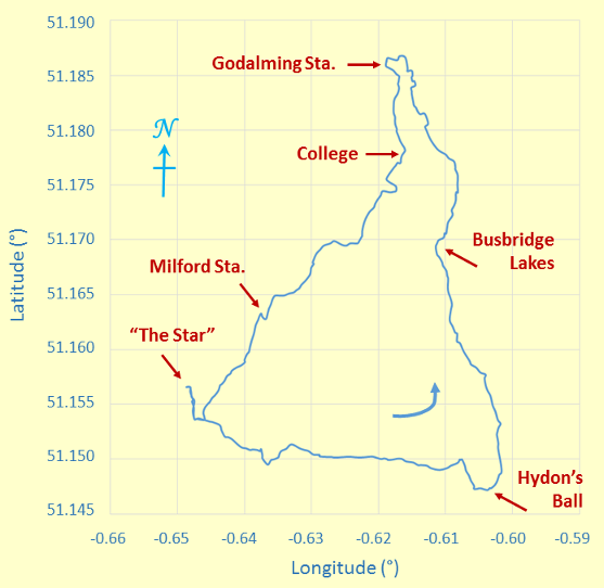
Outline Map of Our Anti-Clockwise Circular - or should it be "Triangular" - Walk
The minus signs for the longitude angles indicate "degrees west of Greenwich". The map grid scales translate to 0.6972 Km per 0.01° longitude and 1.1119 Km per 0.01° latitude, all when using 6371.0 Km as the volumetric mean radius of the earth - as per the WGS84 standard!
Height Profile of Our Walk
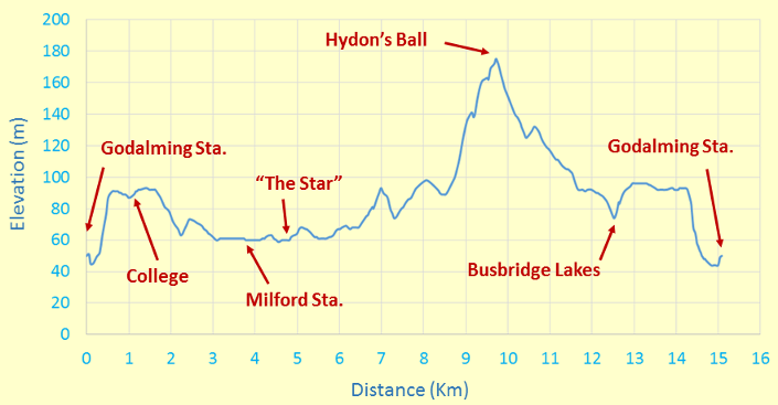
Height Profile
This height profile emphasises that our main climb was in the afternoon to the Hydon's Ball viewpoint at 179 m.. However, the railway line was built somewhere near to lowest part of the area, so that an initial climb was necessary in the morning in order to get to the real start of our walk.
Some Facts and Figures
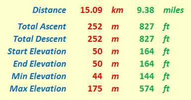
"Walk facts and figures"
Here are some "vital statistics" in metric and imperial units. Of course, the total ascent (here 252 m) usually exceeds the difference between maximum and minimum elevations (here (175 - 44) m or 131 m); I'd suspect things, if the reverse transpired! Start and end elevations are the same at 50 m. Total ascent and total descent are also the same at 252 m - as expected!. I can pat myself on the back (hmm, hmm) for doing the hand plotting reasonably accurately!! The total distance, as always measured on a conceptual "flat" plane at mean sea level, is 15.09 Km or 9.38 miles. Remember, in order to keep our description as general as possible, I have assumed a direct return to our starting point - unfortunately, as mentioned, not everyone who wishes to repeat this walk will have the chance savour Tim's nice cream teas!
Average Rising and Falling Gradients
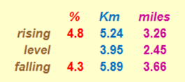
Rising and Falling Gradients
And here, for the numerical fun of it, are the average gradients we overcame on our walk. The rising and falling (negative) gradients are both averaged over the distance given, with level stretches having rises and falls of less than ± ½ metre. By comparison, Hertfordshire County Council recommends that its roads should not have longitudinal gradients of more than 5% and one of the steepest adhesion railways in the world, in Austria, has a maximum gradient of 11.6%. By way of further interest, the clockwise route of the Fairfield Horseshoe in the Lake District has a total distance of 15.62 Km (9.71 miles), with the following calculations: an average rising gradient of 14.66% over 6.589 Km, a level part over 0.345 Km, and an average falling gradient of 11.11% over 8.676 Km. This is seen by many as really quite challenging - but then, when you compare it with our Godalming walk, it can be said that in Godalming we had a more leisurely and less demanding aim compared with Lakeland challenges!
Thanks
Thank you Tim for organising and leading this walk, without hesitation or deviation, and indeed, for imparting to us some of your local knowledge. Thank you all for your good company. It certainly has been a nice and successful day out - lots of nice countryside and good exercise AND excellent weather for walking. A rewarding way to spend Saturday!
Eric Scharf
Original: 2015-08-04 @14:04
SAGAX REX HANC RETIS ORBIS PAGINAM PINXIT ANNO MMXV.