 |
Visit to Grasmere SOME FACTS Easter 2009 |
|
| Where on the Map? Distance Terrain Weather Thank You! Please Read Me |
Where in the U.K. is Grasmere?
Grasmere is a village in NW England and within the Lake District National Park in Cumbria. In addition, Grasmere is situated just off the A591 between the towns of Windermere and Ambleside to the south and Keswick to the north.
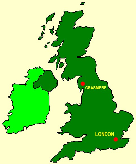
Here you see a "sketch" of the U.K. showing the approximate locations of Ambleside and London.
This "map" is from the Microsoft® PowerPoint® Clip Art Library originally supplied with versions of MS_Office®.
Distance from London
If you espouse the quantitative in life, we have some numbers for you! What are these "great circle distances"? If you haven't met these before, I try, in my humble way, to give a little bit of an explanation below. However, this is probably not the place to wax unduly on the subject!
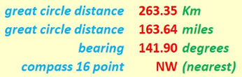
If you espouse the quantitative in life, here you duly see some numbers!
Our "straight line" distances are actually "great circle" distances on the earth's surface. We assume the earth to be spherical, which is not far off the mark. Assuming the earth to be a sphere gives us a maximum error of about 0.1% in our distance values. Not that much really! Can't complain! Indeed, we can speak of the distances as the "hypothetical crow" (cornix hypothetica) flies.

Cornix Hypothetica, our hypothetical crow,
isn't any old bird, as we should know.
Cornix Hypothetica! Many miles for us you go,
with many a "straight line" o'er Earth to show.
Terrain
We were too busy enjoying ourselves, so we did not get around to keeping precise records on our trip! Anyway, it was before GPS systems became widely known and accepted by the walking and hiking communities. However we can make some observations.
| day | walk | metres | feet |
| Thursday | We Arrive | - | - |
| Friday | Old Dungeon Ghyll | ca 400 | ca 1312 |
| Saturday | Patterdale & Helvellyn | 950 | 3117 |
| Sunday | Borrowdale to Grasmere | ca 500 | ca 1640 |
| Monday | Fairfield Horseshoe | 873 | 2864 |
| Tuesday | Loughrigg | 335 | 1099 |
The heights (above sea level) that we reached, give you an idea of the terrain we covered. However, to get a closer idea of our effort in mastering that terrain, we would need to look at our starting height (above sea level). In addition, there are ups and downs on a route; these ups and downs give us a total height which we mastered which is invariably greater than the difference between our starting height and our maximum height! This is where a GPS can give us the information. However, the routes we took can probably easily be replicated, even without GPX files.
Weather
Weather can often yield surprises. However, we had good weather on Saturday, Sunday and Monday. Even on Friday, the rain held off. Thursday and Tuesday were overcast, but overall we had a good innings "weather-wise". We were able to savour the good Lakeland views and our paths were not unduly muddy - just right for walking.
Thank You
Thank you everyone, event organizers, walk leaders and all who helped to make this trip such a success. Even the Weather Gods played their part. We certainly enjoyed ourselves. That was the main thing! Thanks to all for making this a great trip!
Eric Scharf
Version: 2019-02-18 @14:42
SAGAX REX HANC RETIS ORBIS PAGINAM PINXIT ANNO MMXIX.
© Eric Scharf 2019