 |
Heidelberg & Odin's Forest DISTANCE Lotte to London |
|
| How Far ? Earth a Sphere ? Ellipsoid & Geoid Please Read Me |

How far is Hostel Lotte from London?
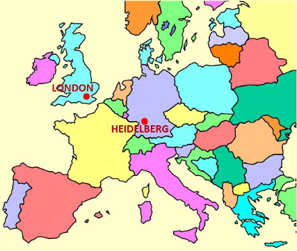
Hostel Lotte in Heidelberg is located at the following GPS (WGS84) coordinates: latitude 49.411338 ° N and longitude 8.712252 ° E. We then look at the centre of London which is officially taken as the intersection of The Strand, Whitehall and Cockspur Street. This intersection is often referred to as Charing Cross, not to be confused with the nearby Victorian Eleanor Cross itself, nor the station in front of which the cross stands. The GPS coordinates of the centre of London are: latitude 51.50730 ° N and longitude -0.12755 ° E.

We then use the WGS84 system, but then assume that the earth - instead of being an ellipsoid - is, for simplicity, a sphere with a volumetric mean radius of 6371.0088 Km. This enables us to find conveniently the shortest distance - as the crow flies - between the two points. This distance is along the circumference of the "great circle" passing through our points of interest, namely, Hostel Lotte and the Centre of London. To find this distance, we use a bit of trig from our school days - a nice little dose of sines and cosines, although still easier than working with an ellipsoid. Who says that trig is boring?
Hence, as the crow flies, Hostel Lotte is 414.6 miles (667.2 Km) east south east (ESE) of the centre of London - with a possible error of about ±0.15% (0.6 miles or 1.0 Km). To be reasonably accurate, the bearing of Hostel Lotte is -20.43° with respect to the centre of London (Charing Cross); ESE is the nearest direction on the 16-point compass scale.
Of course, we are normally earth-bound, and so we must usually navigate bumps and detours in the landscape. This is fun when out walking, but adds some extra miles in addition to our "shortest distance" when we travel across the landscape by any combination of road, rail, canal (?!?) and "foot-power".
Is the Earth Spherical?
To calculate the actual distances along the respective great circles, we have, as stated above, assumed the earth to be spherical. It makes our maths "reasonably" easy and gives us a maximum error of about 0.2% in our distance values. Not that much really! Can't complain!
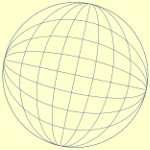
Can we think of the earth as a sphere?
Strictly NO. Practically for our purposes YES.
If you would really like to know more about the 0.2% figure, you could repeat our great circle distance calculations three times, using equatorial, polar and mean earth radii as given in the last figure in the previous above reference on the WGS84 system. Choose a nice enjoyable rainy day for this exercise! To save you the effort (!!), here are the distance error values you would get using the equatorial or polar radius instead of the mean radius of the earth. This is so, since along a great circle on the surface of a sphere of radius r, the distance, on the sphere's surface, subtended by an angle θ (in radians) at the centre of the sphere is "rθ". This formula is always theoretically so, whatever the value, in radians, that the angle θ happens to have for our particular situation or application.
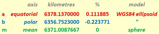
Great Circle distance maximum error values when using
the equatorial radius (a) or the polar radius (b)
compared with using the mean radius (m).
Any point in our part of Western Europe will be at a latitude of between 48° to 52°. Hence the distances of London and Heidelberg to the centre of the earth will both be close to the mean value "m" above. Because of this, distance errors on the earth's surface between London and Heidelberg, when assuming a sphere as opposed to the ellipsoid referred to above, can therefore be expected to be well within the +0.1% to -0.2% range.
Sphere to Ellipsoid to Geoid!
Actually, on this web page, we are still at the modelling stage!! For precise navigation purposes, WGS84, with its ellipsoidal model, gives us a much better idea than the simple spherical model. However, the next stage is to realise that the shape of the earth - with its mountains, valleys and a host of other features, is more detailed than the spherical or ellipsoidal models would have us at first believe. The real shape of the earth is in fact a Geoid.
The Earth is a dynamic entity!
Eric Scharf
Original Version: 2020-04-28 @12:16
Latest Update: 2020-07-08 @12:58
SAGAX REX HANC RETIS ORBIS PAGINAM PINXIT ANNO MMXX.
© Eric Scharf 2020