 |
LINE FEATURES West Somerset Railway 29th August 2017 |
|
| WHERE ? MAP HEIGHTS FIGURES TIMING FILE FINALLY READ ME |
History & Features of the West Somerset Railway
The West Somerset Railway (WSR) opened as a broad gauge line in 1862, to connect the GWR main line at Taunton to the then commercial port of Watchet. It was extended in 1874 to bring holiday visitors to Minehead. Up to 1882 it was broad gauge (7' ¼"). It closed in 1971, reopening as a heritage line five years later. From Taunton to Watchet it runs in the hilly countryside between the Quantocks and Exmoor, reaching a maximum height of 125 metres (!!) (410 feet) at Crowcombe Heathfield. Between Blue Anchor and Dunster the line famously hugs the coast, dipping to about 5 metres above sea level.
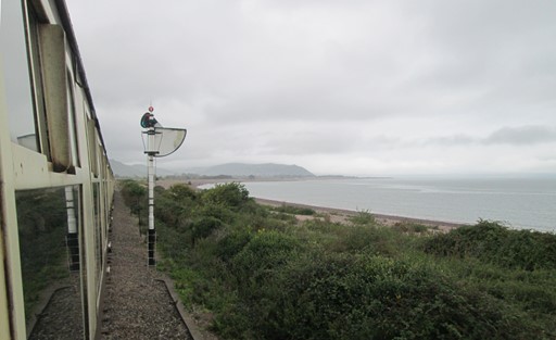
Between Dunster and Blue Anchor, the WSR hugs the coast, giving this view of Minehead.
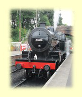
Note the old style signal.
Now prepare ye for some plots and graphs. Not too overwhelming, but hopefully quite interesting! You will see here:
- How far is Minehead Station from the Centre of London?
- Outline Map of the WSR
- Height Profiles of the WSR
- Some Facts and Figures
- Timing & Speed
- Map File
- And Finally
- Please Read Me! Thankyou!
How far is Minehead Station from the Centre of London?
Minehead Station, the terminus of the WSR, is close to the centre of Minehead and close to the harbour. The station is Inn itself is about 234 Km, or 146 miles, west of the centre of London. These figures are based on a bit of Spherical Geometry, taking the centre of London as the intersection of The Strand, Whitehall and Cockspur Street. This intersection is often referred to as Charing Cross, not to be confused with the Victorian Eleanor Cross itself nor the station in front of which it stands. The detailed figures, for the fun of it, are as shown below.
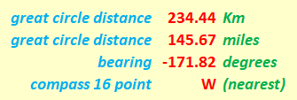
Minehead Station is about 146 miles west of the centre of London.
Waxing a tad technical. Our "straight line" distances are actually "great circle" distances on the earth's surface. In this case, we assume the earth to be spherical, which is not far off the mark. I mean, the shape of our Planet Earth - bumps, warts and all - is called a Geoid. However, the Geoid is far too "bumpy" a candidate for a universal system to be used by a GPS. So GPSs, and Sat Navs in general, use the WGS84 system, which assumes that the earth has the nice smooth regular shape of an ellipsoid; this shape is derived from the mean sea levels (more than one!) found on our Planet Earth. For rough and ready estimates of distance, a further simplification can be made by assuming that the earth has the shape of a sphere as opposed to an ellipsoid, and this simplification can give us a maximum error of about 0.1% in the distance values compared to those given by our GPS. Not that much really! Can't complain! Indeed, we can speak of the distances as the "hypothetical crow" (cornix hypothetica) flies.

Cornix Hypothetica, our hypothetical crow,
isn't any old bird, as we should know.
Cornix Hypothetica, many miles you'll fly,
drawing our "straight lines", in the sky.
Outline Map of the WSR
The WSR strikes very roughly North West from Taunton to Watchet, trying to minimize the inevitable climb in the "gap" between the Quantocks to the east and the Exmoor's Brendon Hills to the west. The sea port of Watchet on the Bristol Channel was the initial main aim of the railway, with Minehead as later add-on, as we said above. There are railway museums at Blue Anchor, Washford and Bishops Lydeard. Steam locomotives are maintained at Minehead and diesel locomotives at Williton. Thus, as is often the case on heritage lines, the various facilities and museums are spread out at different stations along the line.
The map grid scales translate to 1.112 Km per 0.01° latitude and a mean of 0.698 Km per 0.01° longitude (WGS standard), both when using 6371.0 Km as the volumetric mean radius of the earth.
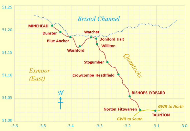
Outline Map of the West Somerset Railway
I plotted the map at home. Because we don't live on a flat earth - unless you are a convinced "flat-earther" - maps are inevitably a distortion of what is. In other words, it's all a matter of mapping a curvaceous surface onto a flat surface. In our case, the northern length of our map grid is stretched out by an extra 0.54 %, to make it the same on the page as the length of the southern part of our map grid. This map covers a larger area than the maps for the walking tracks in our Walk Features Section, so the 0.54% is corresponding larger than the 0.20% for the map of our walking tracks. However, the miniscule loss in accuracy is still not really noticeable!!
Height Profiles of the WSR
To create a reasonably direct route between Taunton and Watchet, the railway was built to run between Exmoor (with the Brendon Hills) and the Quantocks. However, this meant a rise to maximum height of 125 m (410') above sea level at Crowcombe, and a corresponding drop to close to sea level at Watchet. When the line was extended to Minehead, it was deemed necessary to include Washford, and this diversion meant that another height of 55 metres (180') had to be overcome between Watchet and Blue Anchor before getting close to sea level again between Blue Anchor and Minehead. All this had to be included in the railway engineer's plans leading up to 1874, when the last stretch between Watchet and Minehead was opened. Of course railway builders always try to choose their route carefully to avoid the more severe gradients acceptable for normal roads.
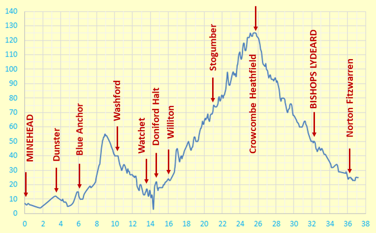
Height Profile
Some Facts and Figures
Here are some "vital statistics" in metric and imperial units. The total length of the line is measured on the surface of the WSG84 spheroid. However, we can consider this, without undue loss of accuracy, as being on a conceptual "flat" plane at mean sea level, using the OS® sea level reference as explained on OS maps. There you are!
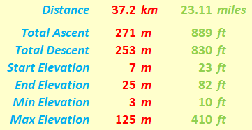
"WSR route: facts and figures"
As normally expected, of course, the total ascent exceeds the maximum height reached. In the case of the WSR, the total ascent is more than twice the maximum height reached.
Timing and Speed
On the WSR, the usual stretch covered is the twenty miles between Minehead and Bishops Lydeard. If it takes 1 hour 25 minutes to cover this stretch, the stops at each of the 8 intermediate stations take up an average of 3 minutes, then the total time on the move is (85 - 8x3) minutes or 61 minutes. The average speed on the move is then just under 20 mph. Of course, these calculations are just for indicative purposes, and no legal statement should be read into them!
Most UK heritage railways are subject to the Light Railways Act of 1896, which stipulated that the speed of 25mph (40.2 Km/h) should not be exceeded. By my humble rough-and-ready estimate the WSR complies with this, even though the WSR is unusual in that it does not, for historical reasons, actually come under the said Light Railways Act.
Map File
If you are keen to see the outline map of the WSR superimposed, if you wish, on an Ordnance Survey® (OS) map or on another system such as Google Maps®, then you can use the following file to do so. As mentioned above, the numerical data in this file have been hand-plotted by me at home. The data are based on WGS84. Of course, for copyright reasons, I do not show the OS-based or Google-based maps here.
And Finally
Any map is an approximate representation of what is, and my plotting thereon certainly is. Practicality and scale are relevant considerations. After all, we are not dealing with a planning application calling for detailed spatial descriptions of intricate boundaries. In this respect, I hope my humble endeavours on this page are interesting for, and useful to, you my reader!
Eric Scharf
Original: 2017-09-28 @14:31
SAGAX REX HANC RETIS ORBIS PAGINAM PINXIT ANNO MMXVII.
© Eric Scharf 2017