 |
T' La'al Ratty MAPS HEIGHTS 19-20 April 2019 |
|
| Where ? Map Heights Figures Timing Track Finally History Read Me |

Features of the R&ER
The 15in gauge R&ER (La'al Ratty) is about 7 miles long, and uses most of the track bed of the original 3ft gauge mineral line (Owd Ratty). Starting in Ravenglass at about 15 m above sea level, the line skirts around the northern foot of Muncaster Fell and then around the southern flank of Blea Tarn Hill to reach Dalegarth (for Boot) at 52 m above sea level. On the way, the line gets close to sea level, shortly after Ravenglass, and then, shortly before Dalegarth, reaches a maximum of about 58 m above sea level. While minerals, especially iron ore, were the original raison d'être of Owd Ratty, today, tourism reigns supreme, visitors being attracted in part by the scenery through which the line passes.
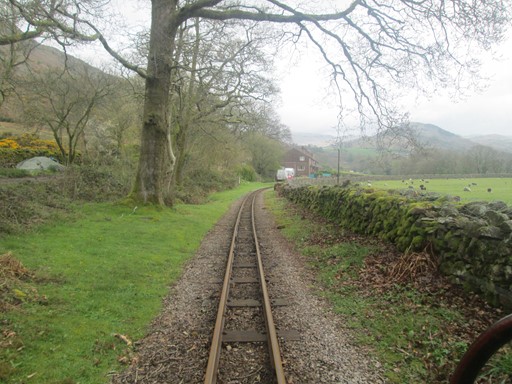
Between Dalegarth and Beckfoot.
Now prepare ye for some plots and graphs. Not too overwhelming, but hopefully quite interesting! You will see here:
- An Outline Map of the R&ER
- Height Profile of the R&ER
- Some Facts and Figures
- Timing & Speed
- Track File
- And Finally
- History
How Far is the R&ER from London?
Ravenglass is on the Irish Sea coast and is the western terminus of the R&ER. Ravenglass lies about 240 miles or 358 Km NW/NNW of the centre of London. The centre of London is officially taken as the intersection of The Strand, Whitehall and Cockspur Street. This intersection is often referred to as Charing Cross, not to be confused with the nearby Victorian Eleanor Cross itself, nor the station in front of which the cross stands. The detailed figures, for the fun of it, are as shown below.
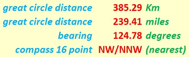
Ravenglass is about 240 miles from the centre of London.
Our "straight line" distances are actually "great circle" distances on the earth's surface. We assume the earth to be spherical, which is not far off the mark. Assuming the earth to be a sphere gives us a maximum error of about 0.1% in our distance values. Not that much really! Can't complain! Indeed, we can speak of the distances as the "hypothetical crow" (cornix hypothetica) flies.

Cornix Hypothetica, our hypothetical crow,
isn't any old bird, as we should know.
Cornix Hypothetica! Many miles for us you go,
with many a "straight line" o'er Earth to show.
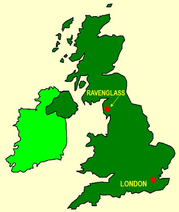
And here you can see Ravenglass in its cartographical context.
Outline Map of the R&ER
From Ravenglass the R&ER wends snakes its way around the northern foot of Muncaster Fell and then follows the River Esk, eventually reaching Dalegarth after Blea Tarn Hill. This is a distance of about 7 miles. In the map, the minus signs for the longitude angles indicate "degrees west of Greenwich". The map grid scales translate to 1.112 Km per 0.01° latitude and a mean of 0.648 Km per 0.01° longitude, all when using 6371.0 Km as the volumetric mean radius of the earth - as per the WGS84 standard! In Guildford, in Surrey, the longitude scale is more (as expected), with a mean of 0.697 Km per 0.01° longitude; in fact, it is 49 metres per 0.01° longitude more than in Ravenglass!
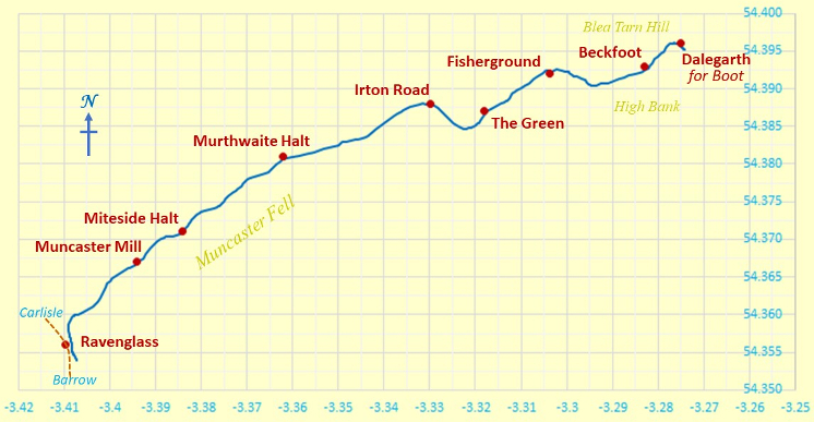
Outline Map of Our Walk
Y and X axes are in degrees latitude and longitude respectively.
Because we don't live on a flat earth - unless you are a convinced "flat-earther" - maps are inevitably a distortion of what is. In other words, it's all a matter of mapping a curvaceous surface onto a flat surface. In our case, the northern length of our map grid is stretched out by an extra 0.12 %, to make it the same on the page as the length of the southern part of our map grid. Not that much for our purposes really! Can't complain!
Height Profile of the R&ER
The R&ER climbs from about sea level to 58m, and shortly afterwards reaches Dalegarth at 52 m. To smooth out possible measurement errors, I have superimposed a "5th order fit" on the height plot. The main climb is between 1 Km and 5.5 Km from Ravenglass. All achievable with R&ER's steam power!
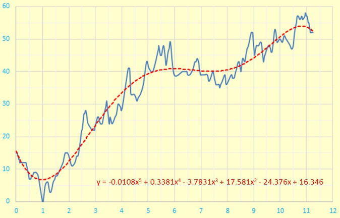
Height Profile
X and Y axes are in units of metres and kilometres respectively.
The above plot uses a true origin for the vertical elevation (height) axis, so as not to lose track of reality. What a worthy aim!
Topographical Facts and Figures for the R&ER
Here are some "vital statistics" in metric and imperial units. The total length of the journey is 7 miles or about 11¼ Km. It's not a completely smooth climb from Ravenglass to Dalegarth, so the total ascent exceeds the difference between maximum and minimum elevations; I'd suspect things, if the reverse transpired!
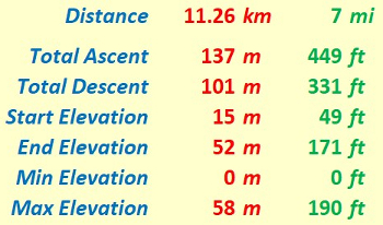
"Walk facts and figures"
Timing and Speed
It's one thing to discuss the terrain over which we travel, but it's quite another to consider how the locomotives - steam and diesel - respond to travelling with a train of nine, possibly fully laden, carriages over that terrain.
It takes about 40 minutes to travel the full length of 7 miles. We can assume a stop of about 5 minutes at passing points. We shall further assume just one passing point - at Irton Road. This gives a total speed of 7 miles per (40-5) minutes or (7x60/35) mph. In other words, 12 mph! This allows passengers time to appreciate the interesting landscape as it glides past them.
Track File
If you are keen to see the railway route superimposed on an Ordnance Survey® (OS) map, then you can use the following file to do so. The numerical data in this file were plotted by me. Hence the data are presented on a "best efforts" basis.
And Finally - a Matter of Practicality
Any map is an approximate representation of what is. Practicality and scale are relevant considerations. We are not dealing with a planning application calling for detailed spatial descriptions of intricate boundaries. However, notwithstanding, I hope my humble endeavours on this page are nevertheless interesting for, and useful to, you my reader!
History
Here I have added two excerpts from old maps, excerpts which highlight the presence of "Owd Ratty" in Boot and its immediate neighbourhood. The Ordnance_Survey® maps are sourced from the Map Section of the National Library of Scotland (NLS) (Link), who state the restrictions in place on the commercial re-use of these maps.
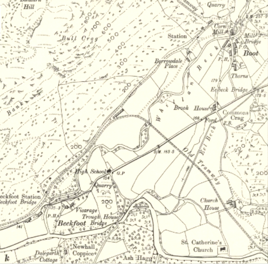
This shows, in the top right, the old station at Boot and the start of the tramway to the mine workings at Nab Gill. In the middle, you can also see where the line curved off to the right, in front of the still extant row of former workers' cottages. The line then continued to the site of the present Dalegarth R&ER station and then proceeded onwards across the road and the present field to the haematite mine workings at Gill Force.
https://maps.nls.uk/view/121146284
Cumberland LXXIX.14 (Eskdale). Revised: 1897 to 1898. Published: 1899.
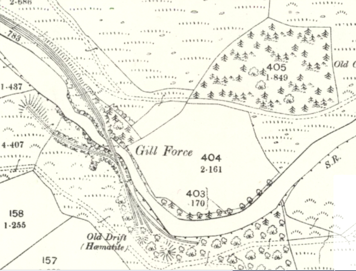
Here you can see the tracks in the old mine workings at Gill Force. These mine workings were accessed by an iron bridge which is still in place across the River Esk. On the north side of the bridge, there was a long siding, parallel to the access track from Dalegarth. In this siding, the empty ore wagons were kept prior to loading, and the full wagons were assembled before being taken down to Ravenglass.
https://maps.nls.uk/view/121146287
Cumberland LXXIX.15 (Eskdale). Revised: 1897 to 1898. Published: 1899.
Eric Scharf
Original: 2021-05-04 @11:12
Update: 2021-09-03 @12:09
SAGAX REX HANC RETIS ORBIS PAGINAM PINXIT ANNO MMXXI.
© Eric Scharf 2021