 |
Downham & Two Hanningfields
WICKFORD CIRCULAR A Walk for All Seasons | |
| Grange Church Downham W. Han'field Café S. Han'field Return Postscript Read Me |
Wickford, Downham and Two Hanningfields
This walk introduces you to the rich tapestry of landscapes and history that provide one of the little known gems of the Essex countryside between Wickford and the southern fringes of Chelmsford. If you start at 10:00 you should be able to complete the walk comfortably by between 16:00 and 17:00, depending on your pace, the number of pit stops and of course the number of stops to admire and photograph the interesting features on the way.
Nice footpaths lead us to West Hanningfield's venerable church (dedicated to Saint Mary and Saint Edward) which has greeted worshippers for over six centuries.
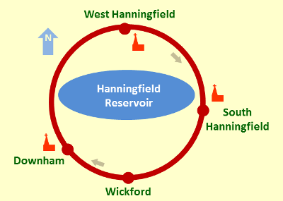
The route takes us through Downham, West Hanningfield and South Hanningfield around what I think is the largest man-made lake in Essex, with its pretty nature reserve and bird sanctuary.
What you will see here
- To the Grange along the old Drovers' Road
- Downham Church dedicated to Saint Margaret of Antioch
- Downham to West Hanningfield
- West Hanningfield
- Diversion to the "Café on the Water"
- South Hanningfield
- And So to Wickford
- Map, Heights and Gradients
- Postscript
- Footnotes
- Contact, Copyright & "Readme"
- Downham Church dedicated to Saint Margaret of Antioch
To the Grange along the old Drovers' Road
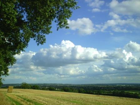
We begin to reach higher ground along a bridle path which was probably an old drovers' road. In the middle ages, such roads tended to take to the higher ground to maximize protection from marauders for travellers, merchants and those driving livestock. From our bridle path we get good views to the East - to Rettendon with its church - and to the South West - to Laindon, to the Refineries and onwards to North Kent.
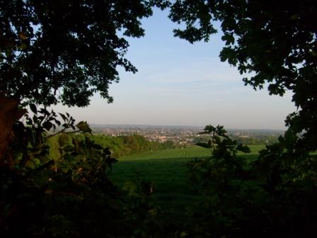
Scaling "the heights" in the northern reaches of Wickford, and crossing the border between Basildon and Chelmsford Councils, you can look south, towards Rayleigh and - on a clear day - the towards the Thames Estuary.
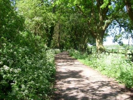
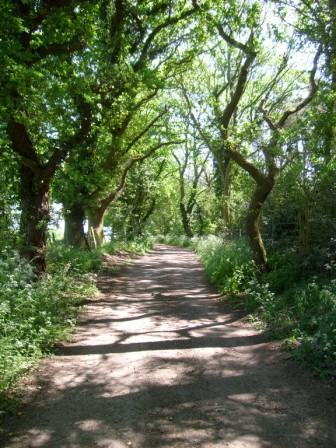
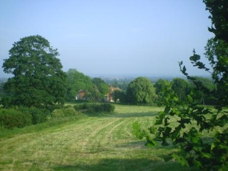
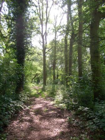
As we walk towards the "Grange", the path becomes pleasantly verdant and wooded. Incidentally, the Grange is a large, rambling, Edwardian house originally built for the family that owned the large "Keddies" store in Southend. The house occupies an outlying spur of the hill we have just climbed. Since Edwardian days, the house has had several owners.
The arcade of trees offers pleasant shade on a hot summer's day.
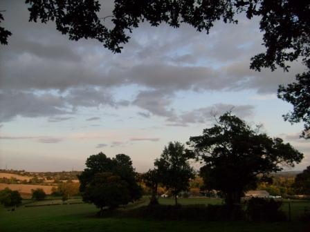
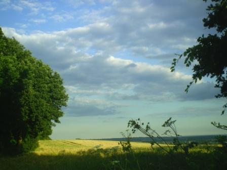
We can look east, as far as Rettendon church, and take in the colourful landscape of a hot summer's day. The dark clouds signify the possible arrival of a thunderstorm.
Elegant - "Country Life" like - abodes climb gently up Brock Hill.
The path along which we have come was an old drovers' road in the middle ages. Its raised position above the surrounding countryside provided some protection against the rouges, scoundrels, thieves and villans, all of whom might have wished to waylay our travellers in ancient times.
We have now reached the northern, and main, entrance to the Grange. We can take in the wide panorama to the south and west. Here we are looking south to the Kent coast and can take in the everchanging cloudscapes.
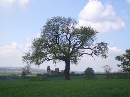
The view towards the west and Billericay takes in Downham Church and is framed by this lovely tree. This view can change dramatically to reflect the seasons and the prevailing weather conditions. To the left of this picture you may just be able to make out Downham Hall. What you are looking at is an example of the local mediaeval axis of power. Between them, the church and the squire (in the Hall) - power divine and temporal - held sway over the local community. Many English villages have this set up - the church, and usually very close by, the Hall.
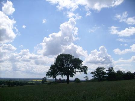
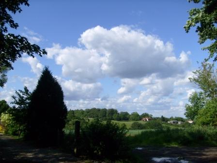
We step back a bit to enjoy the cloudscape.
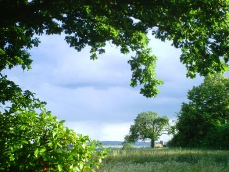
We step back a bit further to appreciate the verdant frame which a lush summer offers us.
Another view to the south to take in the cloudscape. The wheat has just been harvested and the bales of straw may be used as horse bedding for the riding schools which abound hereabouts.
Downham Church dedicated to Saint Margaret of Antioch
We have already had views of Downham Church from the bridle path leading up to the Grange. Many churches were built on promonteries, not only to emphasise their religious significance, but also because their crenellated towers acted as lookouts for, and protection against, those mediaeval marauders we mentioned before. So it is with Downham Church, which is dedicated to the dragon slayer, Saint Margaret of Antioch. The red brick tower is believed to be from the 15th century, but the Victorians "restored" the remainder of the church, which was rebuilt again after a fire in 1977 and subsequently reopened in 2000. In the churchyard on the north side of the church, there stands a gnarled and pollarded field maple, while a sequoia stands guard over the south side of the church. From the churchyard there are extensive views to the South East and the South West, as far as Kent.

Here is Downham Church dedicated to Saint Margaret. Views from the churchyard, with its interesting graves and gravestones, towards the distant Kent coast, provide an amalgam of our mortal existence with the wide open spaces of the surrounding countryside. The lych gate derives its name from the "lych" or body of the deceased person, whose last resting place before burial was often a church gate of this nature. The dovecote was transplanted - a few years ago - from the grounds of Downham Hall which nestles below the church.
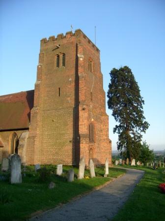
The tudor tower, in all its red brick glory, shines brightly in the sun. The tower and the tall tree, stand guard over the church yard and the surrounding countryside, as they have done for centuries.
Downham Hall - as we mentioned, one end of the local mediaeval axis of power - nestles gently below, and close to, Downham church. Here we see the Hall from the church yard. Whereas many locals had a long trek to divine service on a Sunday, the squire - incumbent of the Hall -usually had the church next door to where he lived, and also usually had a reserved pew in the church! The local squire was often regarded with respect, but also as one who knew a thing or two about a good education and about cultured living!
Downham Village to West Hanningfield
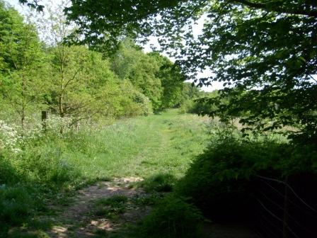
About half a mile from its church is "down-town" Downham, whose houses and village pond exude an air of affluence. Our footpath path out of Downham takes us through Crowsheath Wood, which, in May, is a colourful riot of bluebells. The wood is privately owned but open to the public and maintained by volunteers.

The Downham village sign - as do village signs all over England - makes a proud statement about some important aspects of the village. Not only is the church a landmark, but we also learn that the De Beauvoirs were at one time an important family hereabouts. Note the French name; the Normans (1066 and all that) left their mark, not only on the English language, but also on many family and place names in the South East.
The sun casts pretty shadows on the way to Crowsheath Wood.
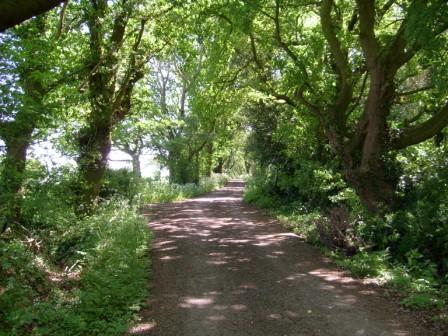
This is the way, via some more woods and fields, to West Hanningfield.
West Hanningfield
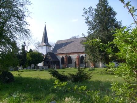
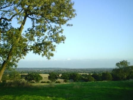
On the way to West Hanningfield we get our first view of Hanningfield Reservoir. Woodland and fields lead us to a small part of Saint Peter's Way, which actually stretches from Ongar in the West to Saint Cedd's Church (one of the oldest in England) on the Essex coast at Bradwell. A splendid Tudor house greets us just before we reach West Hanningfield's pub, "The Three Compasses" dating from the fifteenth century. Towards the east of the village our way passes the church of Saint Mary and Saint Edward, a time-honourd structure going back to the twelth century but enhanced with numerous "add-ons" over the centuries.
West Hanningield is reached by this ghost road, which looks even ghostlier in winter. Some explanation may be needed! This road used to lead to some farms which were swept away when Hanningfield Reservoir was formed in the early fifties out of a suitable dip in the landscape. Now the road just serves as access to the fields nearby. The road is gradually losing its tarmac surface. One can just imagine 50s Fords, Morrises and Vauxalls as well as a few Massey Fergusons, making their rural journeys to and from the long vanished farms!
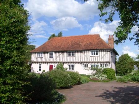
On the outskirts of West Hanningfield we are greeted by this Tudor house (see footnote 1), proudly maintained by its owners, and, ...
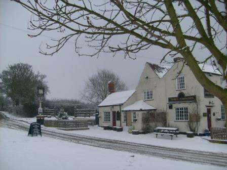
... around the corner is the "Three Compasses" pub dating from the 1400s (see footnote 2).
Further along the village street - or along nice footpaths - we come to the church (dedicated to Saint Mary and Saint Edward) which has greeted worshippers for over six centuries.

From its churchyard on the north side, we can appreciate the organic growth of this venerable building. Bits were added gradually over time, to suit an ever expanding population. A church in mediaeval times was, of course, not just a place of worship, but was also a meeting place for the village it served.
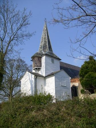
The wooden tower is constructed with typical Essex weather boarding and has a strange round protusion - purpose unknown. The tower is strong enough to support several heavy cast bells, perhaps several tons each.
Diversion to the "Café on the Water"
We leave West Hanningfield and head towards another Hanningfield - South Hanningfield. We have the option of deviating from our route to visit the "reservoir-side" "Café on the Water". The reservoir was built in the early fifties and entailed the destruction of a Jacobean house, "Fremnells" - a name subsequently adopted by a newer house on the side of the reservoir. Unfortunately, the pleasantly sited terrace "Café on the Water" takes last orders at 15:45 and has strict times for lunch and for afternoon tea. As such it is generally not on the schedule for walkers on our route. However, I include some pictures here to show what it would be like if its opening hours were more amenable.
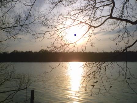
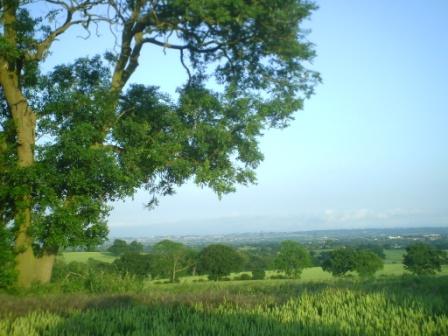
Eventually we come to Hanningfield Reservoir which is a nature reserve, bird sanctuary and fishing lake, all rolled into one. It was completed in the early fifties using a natural dip in the landscape. Its purpose was to meet the water needs of over 0.5 million local residents, which it does successfully by drawing, collecting and purifying water from the Rivers Chelmer and Blackwater. As a sweetener to the locals, including those who lost their farms and an historic Jacobean manor house, the avian and fishing aspects were introduced and presented as new local attractions.
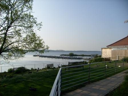
Here is a view of the reservoir from the fishing lodge. Sometimes the area is carpeted with cheeky ducks and geese, eager to see what comestibles the visitors have brought. The wildfowl never get trodden on - by the visitors that is. When the geese have young, the ganders like to show off their hissing sounds. The "Cafe on the Water", a few yards away from here, has a nice culinary fare at a nice price on most days of the year.
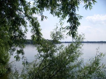
Here is another view of the watery expanse that is Hanningfield Reservoir. Finland in Essex.
South Hanningfield
South Hanningfield's church, dedicated to Saint Peter, goes back to some time between 1180 and 1220. From its churchyard we can get a nice view over Hanningfield Reservoir, a view which can become quite dramatic at sun-set. The nearby well-stocked "Windmill" pub is on our route and is a nice place for tea before our "last leg" into Wickford. The "Windmill"s opening times are much more flexible than those of the above mentioned café.
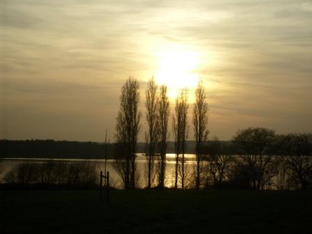
It's a short walk up to West Hanningfield church, from where I took this sun-set view of the reservoir. The poplars seem to have been here for a very long time and certainly add a distinctive flavour to the landscape.
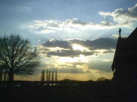
This is another evening view from South Hanningfield church. This is the pleasure of being in the graveyard when it starts to get dark! I'm sure I heard a few tombstones creak as some of the long departed were preparing for their nocturnal cavortings.
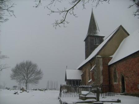
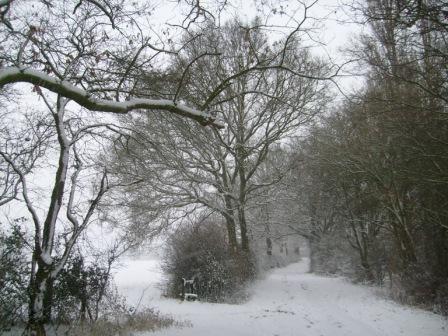
This is South Hanningfield church on a misty, icy and snowy February day. Ghosts are waiting to pounce any moment now!
And So to Wickford
For the last part of our walk we take the path behind "The Windmill", a path that gives us distant views to the South - to Rayleigh and to North Kent. On the way we pass - on our right - Fleming's Farm with its Tudor windows and chimneys. On our right we can also see the outward route along the "drovers' road" - the route that we took at the beginning of our walk. A short walk through Runwell and the northern reaches of Wickford brings us back to Wickford Station, so completing the circle. A nice easy but refreshing walk of about twelve miles all told.
We now take the footpath behind "The Windmill" gastro-pub, which is open most hours for a cup of tea, or indeed, something more substantial.
Compared with weather in the last picture this is a much sunnier day, as we descend into Wickford, all the while enjoying distant views to Rayleigh and to the Kent coast.
Before we reach Wickford we note the still green wheat, indicating that a good harvest is probably in the offing. More bread and Wheetabix® for the populace! On this optimistic note I take my leave from you, my esteemed visitor, hoping that you have enjoyed this short "all seasons" ramble through the Essex countryside.
Map, Heights and Gradients
Our circular walk gives us about 12½ miles (20 Km) of good exercise. We are in Essex, so climbs are more modest than, for example, in the Chilterns. We reach a maximum elevation of about 75 metres (246 feet). In addition, our total ascent of under a fifth of a Kilometre is equivalent to a gentle rising gradient of about 2.4% averaged over about 4.7 miles or 7.5 Kilometres.
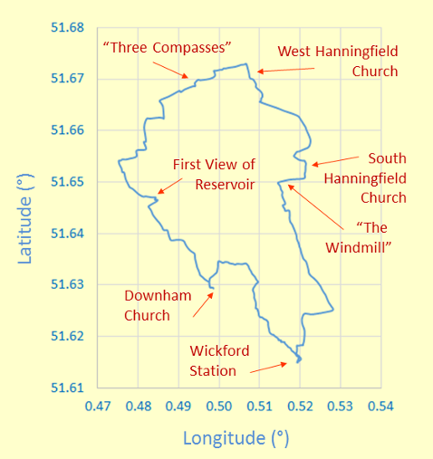
Wickford Station is the start of our "clockwise circular" walk
which, at its northern extremity, takes in West Hanningfield.
The map grid scales translate to 0.690 Km per 0.01° longitude and 1.112 Km per 0.01° latitude,
when using 6371.0 Km as the volumetric mean radius of the earth!
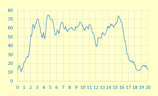
The ups and downs on this graph show you the heights you reach on this walk.
The vertical (y-axis) scale is in metres and the horizontal (x-axis) scale is in Kilometres.
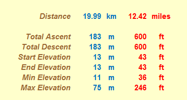
These might at first glance look like a mass of numbers. However, it's what we can read into them that I think is quite interesting. For example, the total ascent is less than a modest ⅕ of a Kilometre, and the total mileage (as always, measured on a conceptual flat plane) is about 12½ miles. As expected, total ascent and descent are the same, and start and end elevations are also equal to each other - as indeed they should be for a circular walk!
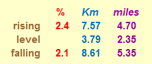
And here, for the numerical fun of it, are the gradients you overcome on this walk. Each gradient is averaged over the distance given, with level stretches having rises less than ± ½ metre. By comparison, Hertfordshire County Council recommends that its roads should not have longitudinal gradients of more than 5%, and one of the steepest adhesion railways in the world, in Austria, has a maximum gradient of 11.6%.
Postscript
This is a walk for all seasons and most weathers, as the pictures you have seen reveal. If you have not done the walk yet, then what are you waiting for? It's only 30 miles by train from London!
Footnotes
- West Hanningfield's "Tudor House". Discussion on 6th February, 2018 at 13:50 with the owner of the "Tudor House" (who had moved in in 1995) revealed that the house had been built between 1480 and 1510. (To put this period into perspective, we can note that Henry VII, the first of the English Tudor kings, came to the throne in 1485). The house had been dated to this period because of the "longwall jetting", which results in a slight overhang of the first floor over the ground floor. The house is similar to a house in the "Downland Openair Museum" in Sussex near Cowdray Hall (remains of) and Petworth. The "Tudor House" in West Hanningfield used to be a farm house for land stretching to West Hanningfield's church and down to the present day Hanningfield Reservoir. The house has had many name changes. The building between the "Tudor House" and the "Three Compasses" pub, around the corner, used to be, at one time, the general stores for West Hanningfield.
- West Hanningfield's "Three Compasses". Discussion on 6th February, 2018 at 14:35 with the lady publican of the "Three Compasses" revealed that the oldest part of the pub, containing the fireplace in the saloon bar, dated from 1425. The name may be from the meeting of three roads at the pub. The pub is often referred to as a "Road House".
- Attribution - Essex Crest. The Essex crest in the header was produced by me using, as reference, my photograph of the crest on the Runwell Village sign.
Eric Scharf
Original: 2011-07-10 @12:18
Updated: 2013-01-13 @16:09, 2014-10-13 @10:16, 2017-11-02 @15:59, 2018-01-22 @14:09 and 2018-02-07 @10:00
SAGAX REX HANC RETIS ORBIS PAGINAM PINXIT ANNIS MMXI ET MMXIV.
© Eric Scharf 2011, 2013, 2014, 2017 & 2018