 |
Capital Christmas MAP HEIGHTS 2006 - 2017 |
 |
| Where ? Map Heights Figures Extra Timing Track Finally Read Me |

Features of Our Walk
This reasonably gentle walk of about 3¾ miles explores the festive nature of the Capital in the week or so before Christmas. The walk itself provides - like a Christmas tree - the structure on which to put the experiences of twelve years (2006 to 2017). The walk can be joined and finished at a variety of places, but you may find that to the nominal length one should add the distances covered at various points of interest! Of course, the heights achieved should be comfortably manageable by most of you!
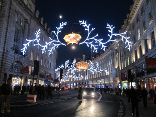
Regent Street 2013
Looking south towards the Quadrant.
Christmas Lights
Now prepare ye for some plots and graphs. Not too overwhelming, but hopefully quite interesting! You will see here:
- An Outline Map of Our Walk
- Height Profile of Our Walk
- Some Facts and Figures
- Extra, Less Quantifiable, Considerations
- Timing & Speed
- Track File
- And Finally
How far were we from the Centre of London?
Our planned walk starts in Knightsbridge and ends in festive glory on Trafalgar Square which is regarded as the centre of London. Well almost. The centre of London is officially taken as the intersection of The Strand, Whitehall and Cockspur Street. This intersection is often referred to as Charing Cross, not to be confused with the nearby Victorian Eleanor Cross itself, nor the station in front of which the cross stands.
Outline Map of Our Walk
Here you see our "linear" walk. It takes in some of the "important" areas which exude the festive atmosphere. These are: Knightsbridge, Oxford Street, Regent Street, Jermyn Street and on to Trafalgar Square. As mentioned later, it shows accurately on Google® Maps, but unfortunately, not on OS® Maps. Anyway, I think, just below, you should get a good overview of the walk.
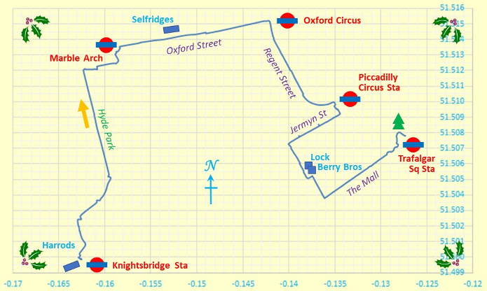
Outline Map of Our Walk
Y and X axes are in degrees latitude and longitude respectively.
Height Profile of Our Walk
The height plot shows that we were quite close to sea level. This is to be expected in Central London. The stepped plot shows that we are close to the resolution of the mapping system, but this should not worry us overly!
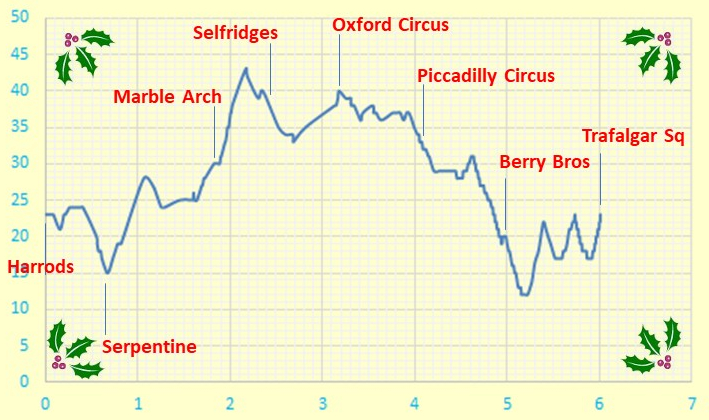
Height Profile
X and Y axes are in units of metres and kilometres respectively.
Some Facts and Figures
Here are some "vital statistics" in metric and imperial units. The total length of the walk is measured on a conceptual "flat" plane at mean sea level, WGS84 style. Equivalence of start and end heights is coincidental! The total ascent should normally exceed the difference between maximum and minimum elevations, which it duly does here!
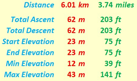
"Walk facts and figures"
Extra, Less Quantifiable, Considerations
On any walk there are considerations which are very real but tantalizingly out of ready reach of those who wish to espouse a numerical approach to many of life's activities. Here are three considerations for starters.
- Weather: On the days I did the walks, the weather was reasonably behaved. Anyway, being in the centre of town, there were many "escape" possibilities.
- Ground Conditions: As expected, even when walking through Hyde Park, there was no mud.
- Signposting: It was centre of town, so sign posting in this context was not really any major issue!
Timing and Speed
It's one thing to discuss the terrain over which we walk. It's quite another to ask how we personally respond to walking over that terrain. There are a number of considerations, of which timing and speed can be taken as starting points. Of course, all this is if you really wish to regard the walk as a physical exercise!
- Distance: The nominal distance was 3¾ miles.
- Speed: Brisk walkers can reach 2½ mph or more.
Track File
If you are keen to see our walk superimposed in Google® Maps or - less accurately - on an Ordnance Survey® (OS) map, then you can use the following file to do so. The numerical data in this file were plotted by yours truly using Google® maps. The data are based on WGS84. Of course, for copyright reasons, I do not show the full Google® or OS-based map here. Furthermore, in practice there will be quite a few walkabouts in shops, hostelries and sightseeing places. What you see here is an outline map which can be embellished, like a Christmas Tree, with what you actually wish to do and see when in this part of London in December.
And Finally - a Matter of Practicality
Any map is an approximate representation of what is. Practicality and scale are relevant considerations. We are not dealing with a planning application calling for detailed spatial descriptions of intricate boundaries. However, I hope my humble endeavours on this page are interesting for, and useful to, you my reader!
Eric Scharf
Original: 2020-12-03 @13:59
Latest: 2020-12-27 @12:19 & 2021-12-05 @17:48
SAGAX REX HANC RETIS ORBIS PAGINAM PINXIT ANNO MMXX ET MMXXI.
© Eric Scharf 2020 & 2021